Data in our landscape championed by Environmental Monitors
Written by: – Keneilwe Mmushi
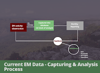
 Initially Environmental Monitors used to send real-time data via WhatsApp to the Data Collator, which was then captured into a spreadsheet and analyzed at the end of each month to formulate monthly reports to funder Department of Forestry and Fisheries (DEFF) and other key stakeholders in the landscape. This was revised with inputs from students from the Central European University (CEU).


The 2019 Environmental Monitors (EM) programme has brought adaptive changes and our data system has also improved!
In addition to the single-levelled data submission of their system, where the EMs submit geo-referenced data of their observations, a column of EM interventions which captures the measures EMs take to ensure that environmental challenges are addressed, has been added. Since a more action-based approach is used, it was seen that a more fitting, user-friendly database be developed to compliment the work done on the ground.
 Initially Environmental Monitors used to send real-time data via WhatsApp to the Data Collator, which was then captured into a spreadsheet and analyzed at the end of each month to formulate monthly reports to funder Department of Forestry and Fisheries (DEFF) and other key stakeholders in the landscape. This was revised with inputs from students from the Central European University (CEU).
A second layer of analysis (more project specific) was added to the existing data system. This layer comprises of a sub-section (schema) which is populated by EM managers, interpretation of the 1st level of analysis to suit each project specifics and enable filtering of relevant feedback to report to the various stakeholder they work with. This layer of analysis allows for better data manipulation through GIS soft wares and thus a more visual, spatialized dataset to include in our feedback sessions and reports to different stakeholders.
The consolidated 2nd level analysed database will in the long run allow us to pick-up landscape trends.


Comments
Post a Comment